
 There are many variations of passages of Lorem Ipsum available, but the majority have suffered alteration in some form,
by injected humour, or randomised words which don't look even slightly believable.
There are many variations of passages of Lorem Ipsum available, but the majority have suffered alteration in some form,
by injected humour, or randomised words which don't look even slightly believable.
There are many variations of passages of Lorem Ipsum available, but the majority have suffered alteration in some form, by injected humour, or randomised words which don't look even slightly believable.
There are many variations of passages of Lorem Ipsum available
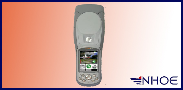
IkeGPS™ products
![]()
Using the World’s most advanced all-in-one
ruggedized location-based measuring tool
IkeGPS™ integrates high accuracy GPS, with a laser range finder, digital camera, 3D compass,
along with ikeTools™
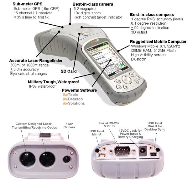
How isIkeGPS™ made?
Why are so many measurement professionals choosing IkeGPS™?
• The all-in-one IkeGPS™ unit along with ikeTools and ikeDesktop improves the efficiency of remote measurements
and processing, saving time and money.
• Captured data easily integrates with back office mapping and database applications such as Google™, ESRI™, and others.
Advantages of using IkeGPS™ for remote location and remote measurement:
• Productivity: IkeGPS™ tools and solutions are more than doubling customer productivity when compared to traditional field measuring methods used in the utility, vegetation management, defense, and energy industries.
• Safety: IkeGPS™ allows your field crews to measure everything from a remote, safe position.
• Capability: IkeGPS™ is the only device that with the single press of a button can collect the local GPS position, the target GPS position, a verifiable photo from which you can conduct measurements. This allows you to quickly collect your field data and allows you to view it on a map and conduct additional measurements later. Additionally, the IkeGPS™ S conducts real time measurements e.g. heights, widths, and distances that are embedded into the photo, providing physical proof of the measurement taken.
• Simplicity: IkeGPS™ is the only all-in-one location-based measurement device to integrate digital camera and laser range finder technologies together with best-in-class 3D compass and GPS. It’s easy-to-use for non-experts and it’s easy to carry around.
• Speed: Using IkeGPS™ tools and solutions, field crews can greatly reduce data capture time and measurement inefficiency.
• Accuracy: IkeGPS™ is as accurate or more accurate than many other traditional measurement devices such as hot sticks and standalone laser rangefinders.
• Verification: IkeGPS™ provides geo-tagged verification of all field work, since every measurement is embedded directly into the ikeGPS photograph, in real time. This means much less rework and back office errors and reduces project completion time.
• Integration: Captured data easily integrates with mapping and database applications such as Google, ESRI, and many other industry applications.
• Customization: IkeGPS™ users can easily create workflows and forms using drag and drop software that can be deployed to your ikeGPS devices with a single push of a button. This enhances productivity and eliminates the need for custom programming.
Most
notably...
No other combination of devices in the market can provide the remote measurement capabilities of IkeGPS™. This is enabled by the unique hardware integration and the powerful IkeGPS™ measurement software engine.
For more information or to order IkeGPS™ accessories, please contact us. |